This tutorial describes how to create a 3D surface model from contour information using AutoCAD and Key TERRA-FIRMA. The requirement to visualise terrain in 3D, whether existing or proposed is very common in the environmental design professions. Landscape architects in particular can benefit from this technique so that new landforms can be designed and effectively visualised before they are physically created. It also enables designs to be checked to make sure they work. For example, screening mounds could be modelled and then tested for effectiveness by creating perspective views from various angles and elevations.
 |
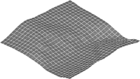 |
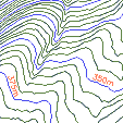
| Contours | Ground model as a 3D grid |
Those of you who need only a quick step-by-step guide or a refresher can go straight to the FastTrack section of the tutorial. For those who are new to TERRA-FIRMA or to Ground Modelling and wish to know more about it, the main part of this tutorial will concentrate on a more in-depth step-by-step guide which will discuss the various concepts involved.