
From time to time, you may need to use a raster image to trace off information. For example, you may want to use a map base to draw the line of a road or to draw some contours. In the past, this would have been done using a digitising tablet and although AutoCAD still supports the use of tablets, the new image support options have, in many respects, made them redundant.
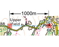
However, the only way to create an accurate drawing from a raster image is to accurately scale it. AutoCAD can help to scale some images if the file format contains information about the image resolution. This is more likely to be a special case rather than a general rule. The technique described below can be used to scale any raster image in such a way that units on the scanned map or plan correspond to AutoCAD drawing units. It works even if you do not know the image resolution. The only piece of information that you need is a known length that is easily identifiable on the plan. The length of a wall, the width of a road or the distance between grid lines can all be used to scale a raster image providing you can accurately pick each end of the measured length.


